David Ellyard AAE Report 2012 Voyage
THE COMMONWEALTH BAY ADVENTURE

DAY 1 (6 JANUARY 2012)
As I sit here typing, the boat on which I am travelling south, the bright orange-red Aurora Australis, is rolling back and forth beneath and around me. Not very big rolls, maybe up to 10 degrees either way, but the biggest will throw you off-balance if you are walking, and make light objects slide around on the desk. It is swell rather than wind-driven waves. I can see just a few white caps through the porthole. But we heading across the “Roaring Forties” that furrow the southern ocean and the swell is hitting us side on. From time to time the bow digs into a wave with a thump and a flurry of spray.
Just back from breakfast on the first morning. Quite lavish, hot and cold, as you might see in a good hotel. Given the rolling, the attendance was modest, and crew members outnumbered the expeditioners. The doctors handed out the “little white pills” last night to those who thought they might need them and a few of my fellow travellers reported the early signs of sea sickness; lethargy and headache. It seems that you can be suffering from “mal de mer” long before you feel like throwing up.
We finally pulled out of Hobart just before midnight (on 5 January). This trip has been delayed by bad weather twice and we are now nearly a week late. Once onboard, we found our cabins (I have one to myself), attended various briefings on what and what not to do in the interests of safety, cleared customs, toured the ship (with particular attention to the lifeboats), tried on the “immersion” suits intended to keep and afloat and alive should we need to bale out, had dinner and introduced ourselves around.
There are about 50 on board, plus the crew. A lot of them are scientists of various kinds, since the second half of the trip will be devoted to a marine science survey ending in Fremantle. More on that later, but to make one observation. To judge from the sample on board, the typical marine scientist is female and 30-ish. Since the first part of the trip celebrates the centenary of the 1911-1914 Australasian Antarctic Expedition (AAE) led by Douglas Mawson, we have various VIPs aboard. Again, more on them as we move along, but most seem to be male, though the Archibald Prize-winning Wendy Sharpe is with us. The doctor and the Deputy Voyage Leader are both women, so the gender balance is about even.
Beyond all that, not a lot to report so far, only half a day in to the voyage. Bu the prospect of landing at Commonwealth Bay and seeing the iconic “Mawson’s Huts” is very exciting. Stay tuned, and I will take you there.
DAY 2 (7 JANUARY 2011)
Saturday at sea, heading south from Hobart. It is starting to get cold. As of yesterday afternoon, air temperature was 12 degrees, water temperature about the same, but both are dropping. We are now around 50 degrees south latitude, making about 4 degrees of latitude a day (250 nautical miles). ETA at Commonwealth Bay is the 11th.
The ship is still rolling a lot but in bursts. We can have 10 or 15 minutes of gentle stuff and then a series of 10 or 15 degree rolls each way that have you holding on to things. If you are on the move you are walking uphill one moment and downhill a few seconds later. The forecast has the seas abating during the day but picking up late afternoon. Skies were grey early but I can glimpse blue through the porthole now.
I walked on deck yesterday afternoon, part of a daily exercise routine I am hoping to maintain. I can almost circle the ship, including an orbit of the heaving helicopter pad. The moving white-capped ocean is empty to the horizon, though we are being followed still by albatross and petrels.
I find it always a humbling experience, not only an awareness of immensity but the knowledge that earlier mariners ploughed these often fierce seas, and the ice that lies further south, in seemingly-frail wooden windjammers, one tenth or less the size of the steel-plated, diesel-powered monster I am travelling on.
So why do we come? Antarctica has drawn us over the last 200 years for a variety of reasons. Initial interest was commercial, exploiting the seals and later the whales found in abundance in these waters for furs and oil and other useful products. From the mid 19th century, exploration and science took over, mixed in the early 20th Century “heroic” era with flag-waving and a desire to pit human will-power and endurance against a harsh and unforgiving landscape.
For a time geo-political considerations led to often-conflicting claims for sovereignty, and commercial interest was sparked again by talk of mining and drilling, but international agreements have largely shut those issues down, if not entirely. Now the over-riding concern is to understand and conserve the Antarctic environment as the last great wilderness, though fragile enough to be affected by human activity.
Such studies are part of our purpose this trip, though the emphasis is on the waters surrounding the continent. The other, and earlier, focus is historical. We plan to go ashore at Commonwealth Bay, almost due south of Tasmania. Almost exactly 100 years ago, a party led by Douglas Mawson set up a base there, and built huts which still stand. By this visit we will commemorate the centenary of an enterprise that began Australia’s engagement with Antarctica, still very active today.
More on all of this as we move along.
DAY 2 (7 JANUARY): POST-SCRIPT
Just in from a late walk on the deck. Though it was well past nine, the clouded sky was still bright enough to read a newspaper. A taste of the lingering twilights (the “white nights”) enjoyed in summer at high latitudes. The departing sun was hidden, but coloured the clouds enough for us to find it far round in the southwest, just a little to the right of our southward track. Again, something seen only well away from the tropics.
After several days of thumping, the benign face of the southern ocean was on show. The wind had eased away, the air almost balmy, the tracery of clouds subtly coloured. The sea was all but flat most of the time, white-capped only from our wake, and the ship glided in response, though willing to give enough of a shiver from time to time to remind us where we were. The near-ground was dominated by the sounds of the ship, but further out, we could tell, it was calm and quiet. There may be more vigorous weather ahead, and there will be ice, but tonight was memorable.
The captain, Murray Doyle, turned 60 yesterday. We shared his birthday cake. Today he turned back the clock to compare his 100-metre steel Aurora Australis with Mawson’s 50-metre wooden Aurora, at least in terms of the tools their masters had to navigate with. Standing on a bridge dripping with technology, he reminded us that the Aurora’s captain JK Davis had no GPS, no gyro-compass, only a magnetic compass whose reliability was compromised by the nearness of the magnetic pole. The maps he had were decades old and mostly blank in the regions of interest.
Without weather satellites and regular radio reports, forecasting was mostly a matter of watching the clouds and the barometer. Navigation relied on sighting the sun or a bright star with a sextant, which required a sky sufficiently clear and a boat that did not roll too much. To judge his ship’s speed, he dropped a log over the stern and counted how fast a rope attached to it ran out. Murray Doyle has much better ways to do all that nowadays, but that serves to build admiration for the skill and tenacity of sailors in hazardous waters without such aids.
There was an additional thing to admire about Master Doyle, other than his obvious command of his job. As the ship humped this way and that, the rest of us kept moving our feet to keep our balance, not always with success. He kept his feet firmly placed and simply swayed back and forth to keep himself up-right, probably not aware he was doing it, so practiced was he. Now there’s a skill.
DAY 3 (8 JANAURY 2012)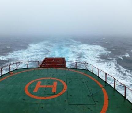
I woke this morning to a smoothly-sailing ship … just a little gentle rocking…but a featureless grey sky and a misty horizon. We have now crossed an invisible border in the ocean known as the Antarctic Convergence (or the Polar Frontal Zone). This forms the natural edge of the Antarctic realm; dense cold water from the continent sinks below warmer water from lower latitudes. The sea temperature drops suddenly; that helps explain the mist. It is also noticeably colder on the ship; yesterdays T-shirts are being replaced by jumpers and hoodies,
The convergence has a big effect of wildlife. Heard Island, just south of the line, is surrounded by cold water, and so is icebound and largely barren. But Kerguelen, only a few hundred km north, is across the boundary, and has much more vegetation. For political and administrative purposes, Antarctica begins at 60 degrees south. We should reach there tomorrow. First-time crossers of the Line may get a visit from King Neptune. Soon after, perhaps, the first lonely icebergs; a day or two on, the first sea ice. The coast will then not be far away. Excitement is building.
This is a working voyage for the many marine scientists on board, and they are already at it: filtering seawater for phytoplankton, the microscopic floating plants that support the whole southern ocean food chain; trawling for larger beasts (an apparently unknown pink worm-like creature has caused some excitement and reported generated media coverage back home); measuring the temperature, salinity and dissolved oxygen of the ocean at various depths. This is partly to understand the behaviour of the Antarctic currents which (as I am learning) are a vital element of our planet’s response to climate change and increasing carbon dioxide. We all have a lot riding on this research.
There has just been an announcement of a muster drill in a quarter of an hour. We need to gather on the helicopter-deck, appropriately dressed and wearing life jackets, for a roll-call when the alarm goes. More later.
THE COMMONWEALTH BAY ADVENTURE DAY 4: 9 JANUARY 2012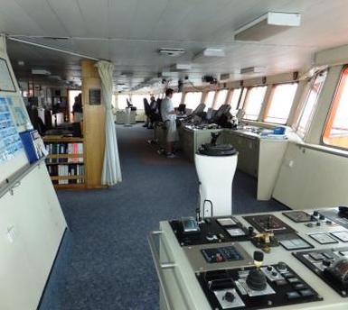
A century ago today, the men of the AAE were unloading their first stores from theAurora, work cut short (as it so often was) by a blizzard that coated everything in ice. We are still two days away, gliding south through almost calm seas, the way ahead shrouded in fog and low cloud. It is as if we have to pierce a veil before Antarctica will reveal itself.
We are getting ready for the encounter. This morning we were briefed in helicopter operations and practiced getting into the “immersion suits” designed to save our lives if we have to ditch. Putting one of those on is quite a task, but then it needs to be. The “fast ice” (sea ice more than a year old and attached to the shore) reported extends out 15 km from the coast, which is a bit far to walk. Hence the need for the choppers. We may be able to break some way into the fast ice, which will be a metre or more thick, and so would not need the immersion suits, but we will see.
As the world knows by now, this whole venture has been complicated by a huge rogue iceberg which has chosen to park itself just offshore from Commonwealth Bay. This has interrupted the usual movement of the “pack ice” (fragments of sea ice from last winter), causing it to pile up on the eastern side of the berg, where it is impeding the movement of some of the tourist ships that were hoping to join us at CWB. But Captain Murray thinks there will be a clearer passage to the west, with the prospect of reaching the edge of the fast ice. Fingers crossed.
Things are getting busy. This afternoon, we will all meet to discuss the plans for Commonwealth Bay activities in general, and for the ceremony that will mark the centenary. At the moment, the weather forecast offers a window on Wednesday 11th, between blizzard bursts on Tuesday and Thursday, and the management is keen to seize that opportunity. Again we shall see. We can make no demands of Antarctica.
A sheet has gone up on the mess-room notice board for a “first iceberg” guessing competition. The Captain reportedly thinks “not yet”, though on other voyages icebergs have been seen further north that we are now (about 59 degrees south). It is now getting noticeably cold. On deck all our winter gear is needed for comfort.
The marine scientists keep at it; continuously filtering plankton to give an inventory of micro-life along our track, deploying instruments to measure water temperature and salinity at depth, and to bring up water samples for other studies. We have to stop for some of those. The salinity probe actually measures how well the water conducts electricity. This evening they will be setting loose an Argo floating buoy to take such measurements automatically. I am told the machine will go overboard in a cardboard box to limit damage as it departs the ship; that will reduce the spectacle.
We are enjoying a series of talks about various aspects of the AAE operations. Last night with Tom Griffiths, we heard the reminiscences of the men; this afternoon our resident forecaster Lance Cowled will remind us of the trials and tribulations of the AAE met men as they tried to keep a record the wild weather. Here, perhaps more than in other aspect of the AAE routine, dedication and endurance were crucial.
THE COMMONWEALTH BAY ADVENTURE Day 5: 10 January 2012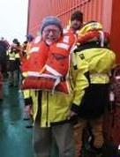
Big excitement! We must be getting close. The first iceberg was sighted this morning, first on the ship’s radar and then visually, but it was small and distant and looked rather like a cloud in the murk. Still, one of our number, a Frenchwoman scientist, won the guessing competition for the time of first sighting. 0804 to be precise
Soon after another one was visible, still quite small but much closer, through the porthole of the mess where we were having breakfast. Soon after that we were passing through patches of “brash ice”, not thick enough to be called “pack ice” yet, but it shows what is ahead. Here and there too some “bergy bits”, fragments of icebergs in the last stages of disintegration after their long journey north from the Antarctic coastline. Icebergs are chunks of the Antarctic ice cap which have broken away in a process called “carving”.
Pack ice on the other hand results from the freezing over the sea to a depth of a metre or more during the winter. “Sea ice” extends hundreds of kilometres offshore, effectively doubling the size of Antarctica during the winter months. With the coming of spring most of the sea ice thins and breaks up, with winds pushing it northwards to form the barrier of the pack which can still be a major impediment to reaching the Antarctic shoreline, and was even more so in the early days of wooden sail-powered ships. It is amazing that Cook, Ross, Wilkes, Dumont D’Urville and the other early Antarctic navigators got anywhere near the coast.
The barrier of the pack ice, combined with the stormy winds and high seas and the long distances to be travelled, resulted in Antarctica being the last continent discovered. Though long suspected to exist (and fancifully marked in as Terra Australis Incognita… the Unknown South Land… on 17th Century maps) , it was only sighted for certain in the 1820s, and that was the relatively accessible region of the Antarctic Peninsula, close to South America and well to the north of most of the Antarctic coastline. Even by the time of the AAE, nearly a century later, nearly all that coastline had never been seen, let alone charted. Mawson and his men were entering unknown territory.
Things have changed quite a lot for us in the last 24 hours, at least in terms of our plans. The weather forecast now says that the Wednesday window I spoke of yesterday has closed and so we now plan to get Commonwealth Bay on Friday, hopefully for a landing but that still remains uncertain. Antarctica will have the last say, as it always does.
So we have changed course a little to the south-east, moving down the eastern side of the jumbo iceberg B9B which blocks the direct route to Commonwealth Bay. We will spend a day or two doing some marine science, and also hopefully getting a view of the Mertz Glacier, one of the two (the other being the Ninnis) lying east of Commonwealth Bay and commemorating Mawson’s two companions lost on the disastrous eastern traverse during the AAE.
Seeing the Mertz depends to some extent on the weather clearing. It remains very cloudy and foggy, for the third day. Lance the weatherman tells me this is due to the winds bringing down moist air from the north. Where that air passes over the very cold water around us, fog and low cloud quickly form. The seas have also picked up a bit; there are white caps on the waves for the first time in a couple of days. And the boat is rolling more. Objects have begun sliding around on desks again.
I will put on all my gear shortly and get up on deck for some photographs of the icebergs and the early pack which I can send you. But there is no particular hurry. The big photogenic icebergs still lie some distance ahead of us and we are sure to see plenty. R right now, the views through the porthole shows an empty ocean. I am also looking forward to entering the silence of the pack ice. The swell will settle down and the only noise will be the grinding of the ship as we push our way through.
PS As of noon, we should be at about 64 degrees south latitude (and about 145 degrees longitude, if you want to get out the atlas). So we are only a couple of degrees shy of the Antarctic Circle, beyond which lies the “Land of the Midnight Sun”.


THE COMMONWEALTH BAY ADVENTURE DAY 5: 10 JANUARY 2012: EVENING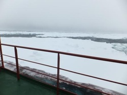
Our fifth day at sea is drawing to a close. The sky is overcast with cloud but while it will dim a little more it will not go dark. That is the benefit of being so close to the Antarctic at this time of year.
Every now and then a sighing sound passes down the sides of the ship, now moving at a reduced speed. The noise is that of floes of pack ice, split by the impact of the ship’s bow, scraping gently along its length. The strength of the ship easily deals with any of the floes we have encountered so far, but the collision still generates a thump and a slight shudder.
Throughout the day the pack ice has become more dense, and the individual floes larger. Some are 20 or 30 metres across, all are one or two metres thick, and often crowned with drifts of snow. Brilliantly white on top, they show a vivid blue from beneath the water and the lower layers, revealed where the impact with the ship has fragmented them or turned them over, are often stained yellow, perhaps from algae. Some give evidence of more than one year’s growth, of sea ice that did not break out after a single winter.
Tomorrow perhaps we will begin to see seals resting on some of the floes, and certainly they will crowd together more tightly. At the moment perhaps half the sea surface is covered in floating ice, at least in some places.
After an initial rush of half a dozen iceberg sightings, including one perhaps only half a kilometre from the ship, they have become more elusive. The grey sky and murky conditions make them difficult to see at any significant distance. But we do anticipate seeing more as we draw nearer the coast and to points where icebergs are calving.
Tonight we heard from Tony Fleming, the newly appointed director of the Australian Antarctic Division, the government agency which runs our Antarctic program. He has an illustrious Antarctic pedigree. His grandfather and two great uncles were members of Scott and Shackleton expeditions in the “heroic age” of Antarctic endeavour.
In particular he spoke of his grandfather, Raymond Priestley, who with five companions endured extraordinary privation when the ship which was to take them home was blocked by sea ice. They survived in a snow cave with very little food for seven months, before saving themselves by sledging 400 km back to their base.
We are thinking a lot at this time of Mawson’s endurance but the hardiness he displayed was found among many of the Antarctic pioneers. Modern-day expeditioners who know their stories feel privileged to be following in the footsteps of such men.
THE COMMONWEALTH BAY ADVENTURE
DAY 6: 11 JANUARY 2012: MORNING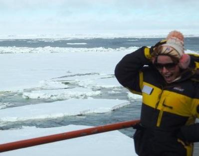
Today’s news is that we are currently sailing when no one has sailed before. Let me explain. As I write we are at about 67° South (just inside the Antarctic Circle) and 146° East, sailing some 7 km offshore from the Mertz Glacier. We can see the ice cliffs that form the face of the glacier stretching along much of the southern skyline, visible as a thin white line between the grey-clouded sky and the ice-strewn sea in the foreground. The face of the glacier is immense, perhaps 100 km long.
All of the Antarctic ice cap, all 30 million cubic kilometres of it, arranged in a huge dome up to 5 km deep, is in motion outwards towards the coast. Some parts are moving noticeably faster than the rest and these are recognised as glaciers. If conditions are right, the glacier can push offshore and float out sea for some kilometres, forming a glacier tongue. So it was till recently with the Mertz Glacier.
The arrival of our friend B9B changed all that. This vast iceberg, 100 km long and 30 km wide (though now broken into three) originated in the Ross Sea, south of New Zealand and hundreds of kilometres to our east. As it drifted west, carried by the current, it hugged the shoreline, colliding with the end of glacier tongue and breaking it off. Where there was a large slab of floating ice, there is now open water, the water we are sailing through. Some fragments of what was here are now far to the west, offshore from our base at Davies. They include some containing instruments placed there some time ago by our on-board French glaciologist Benoit. He is keen to recover them.
So this part of the Antarctic offshore is virgin territory. Naturally our marine scientists are very excited and they are busy taking water samples and measurements of temperature, salinity and oxygen content. The ship will be stopping from time to time throughout the day so they can lower their instruments overboard. At one point we will be passing over a trench dug in the seafloor by the glacier when it was very much larger during the last ice age. The trench will contain cold dense water dumped there last winter. Our head oceanographer Steve is keen to sample that.
This may all sound rather esoteric, but it is part of a bigger endeavour, to understand more fully the way currents operate around the Antarctic coastline, since this is an important element of our planet’s response to climate change. The rest of us are excited too, just to be sampling a unique environment that most people will never experience directly, cruising through ice-filled seas, gazing upon the edge of the world’s last great wilderness.
It has been suggested that I should say more about why this voyage is important, that is beyond the science we are doing, significant as that is. You know this voyage commemorates 100 years since the beginning of the Australasian Antarctic Expedition (AAE). That enterprise was the first big Australian push into Antarctica, though some Australians had been involved in previous endeavours. So it is commonly looked upon as beginning of 100 years of our national engagement with Antarctica.
This voyage also commemorates Mawson the man. Before the AAE he had already demonstrated his qualities as an Antarctican, his impressive physical hardiness and resilience, his potential for leadership. But his legend was set in stone by his epic lone survival during the AAE. With companions Xavier Mertz and Belgrave Ninnis, he set out from the Cape Denison base as one of a number of exploration parties to the east, west and south. The story of the eastern party, which should be known to every Australian, has been recounted many times, including by Mawson himself in The Home of the Blizzard. I briefly summarise it here.
Hundreds of kilometres from the base, Ninnis was lost in a crevasse, falling to his death along with the best dog team and much of the supplies and equipment, including all food for the dogs. Mawson and Mertz turned back at once, eating the dogs as they died one by one from starvation and their own food ran short. Poisoned, as we now know, by the high vitamin content of the dog flesh, Mertz rapidly weakened and died. Mawson, now alone and increasingly ill, struggled on. He fell into many crevasses himself but survived, mostly through the sheer power of his will and ingenuity.
When after further weeks of intensive privation he arrived back at the Cape Denison base, it was to see the relief ship steaming away, leaving to pick up the western party before the season closely in. Men had remained behind to wait for him and the others, and with them Mawson spent another winter at Commonwealth Bay while his shattered body slowly recovered from the ordeal. It is a powerful saga of endurance but, as I commented yesterday, such tales are not uncommon in the history of Antarctic endeavour.
When I was in Antarctica for a year in 1966, I was stationed at Mawson base, named after the great man. That was an honour for me, as Mawson had been a hero since my childhood. Perhaps you can therefore understand the intense anticipation I feel at the prospect of stepping ashore at Commonwealth Bay in a few days time.
THE COMMONWEALTH BAY ADVENTURE DAY 6: 11 JANUARY 2012: EVENING
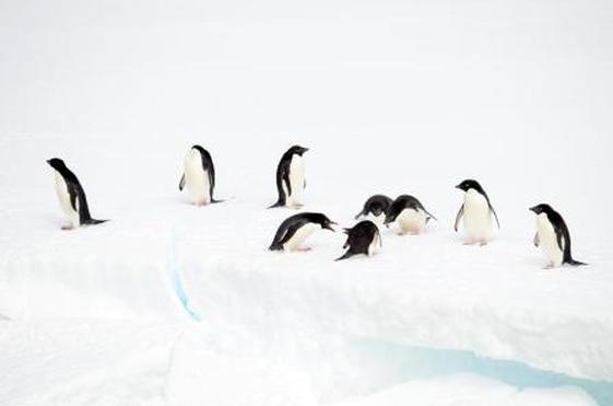
Seen on a passing ice floe; a penguin committee & others just not
interested. (Photo by Karen Barlow)
Nearly 9 o’clock. Quite bright outside though overcast. It would be good to see the sun for more than a few minutes. We are just inside the Antarctic Circle, around 67° so it is likely the sun will not set tonight. At the moment the ship is stationary. No doubt the marine scientists are doing their business at the back end.
Part of the pleasure of this trip has been the many talks and presentations we have enjoyed, all preparing us for the big moment when we step ashore at Commonwealth Bay. This afternoon’s subject with penguins, particularly Adelie penguins, the feisty black and white guys who are the “Mexicans” inHappy Feet. These are “true” Antarctic penguins, which breed only on the Antarctic mainland and they are found all round the coast. Two of the on-board experts, Colin Southwell and Louise Emmerton, talked about their research and their findings.
They have been doing large-scale population surveys, finding that the numbers of these penguins in “our” part of Antarctica (that is, East Antarctica, below Africa, the Indian Ocean, Australia and New Zealand) are increasing, whereas in West Antarctica, such as around the Antarctic Peninsula near South America, the numbers are going down. It is not quite clear why this is so, though there is evidence it has something to do with the amount of fast ice.
In a new development the researchers are setting up solar-powered cameras overlooking a number of penguin rookeries. These will take one picture a week and enable the researchers to chart the growth and decline in numbers throughout the season. They will be setting up one of these cameras in a rookery at Cape Denison. They are also attaching radio transmitters to recently-fledged penguins so they can track their movements. Some of the findings are astonishing, with penguins willing to go 100 km offshore and maybe 4000 km up and down the coast in a year in search of food.
In one rockery some penguins have been electronically tagged and fences built so that they can enter and leave their rockery only by passing over a weighbridge. This allows the researchers to track their changing weight throughout the season. Adelie penguins have been designated an “indicator species”, whose numbers reflect other things harder to track, such as the availability of food in the sea. All fascinating stuff, and we were impressed with the enthusiasm and dedication of the researchers.
Tonight our attention turned to Mawson’s Huts, All being well, we will be seeing, and hopefully entering, them on Friday when we get ashore at Commonwealth Bay. We heard from Ian Godfrey, who has been involved in conservation of the Huts for a decade or more. Over that time much has been done to secure the Huts against the fierce elements found at Cape Denison, to clear out much of the accumulated snow and ice and to collect and conserve artifacts from around the site. The original roofs have been covered with new timber to protect the snow-blasted originals, and to reduce the amount of snow getting in. Already the new timber is weathering so it no longer looks out of place.
You will forgive me if I reserve any other comments about the Huts until after I have seen them. Visiting this historic site is the high point of this trip, and I don’t want to give it all too soon. In the meantime we have plenty to look forward to tomorrow; our arrival offshore at Commonwealth Bay, a celebratory barbecue on the trawl deck with “a couple of drinks” (this has been a “dry” ship since we left Hobart), and a visit from King Neptune and his retinue, who will initiate those unfortunates who have crossed the 60° south line for the first time. All in all, it promises to be a fun day
THE COMMONWEALTH BAY ADVENTURE DAY 7: 12 JANUARY 2012
What a magical day. I have just come down from the bridge. I could hardly tear myself away from what I was seeing, but I need to tell you about it.
At the moment we are cruising west, en route to get round the troublesome B9B iceberg so we can head south into Commonwealth Bay. It is overcast, but everything else is just right. The sea is almost flat with just the smallest ripple. There is hardly any wind, so that it does not feel cold (at least for a few minutes) even though the temperature is about zero. It is snowing lightly and big flakes are falling almost straight down into the sea and onto the ship (and onto us when we slip outside to take photographs). All is silent, with only the gentle throb of the ship’s engines to break the stillness, and we hardly notice that. It is a winter wonderland and a privilege to be here.
The water is mostly open but there are many large floes and much smaller ice round us, stretching to the horizon, and sometimes in our path. From time to time we slice through them. On the bridge you hardly notice the impact but from down here closer to the waterline we feel the bump and the shudder and hear the gentle scraping along the sides of the hull. A few of the floes are populated with a penguin or three, and there are a surprisingly large number of birds swooping and wheeling over the ship, mostly Antarctic and Cape Petrels, hard to catch on with the camera, though I have tried.
Many of the floes carry deep deposits of snow, and this generates a stunning colour affect where a small crevice or cavern has been created. Light filtering through the snow illuminates these spaces from within with an electric blue, contrasting with many subtle shades of white from the ice and snow, and the green of the submerged parts of the floe, seen through the water. It is wrong to say, as some do, that Antarctica is devoid of colour. Certainly it is not loud and brassy; rather it is discreetly tinted, but none the less pleasing to the eye.
We are keeping our distance from B9B. Its long northern edge lies about 15 km away on our left (port/south). Closer in the pack ice is much thicker; at this distance we can make our way quite easily. I am told we will turn south in two or three hours; there after at least a 10 hour run will be needed down the western side of the iceberg(s) to reach Commonwealth Bay. B9B covers a whole degree of latitude, so it is 100 km long north to south. We are likely to arrive off the fast ice in the middle of the night, but I think quite a lot of people will stay up to see it. It will not be getting dark.
THE COMMONWEALTH BAY ADVENTURE DAY 7: 12 JANUARY 2012: EVENING

Russian Antarctic tourists drop by to say hello.
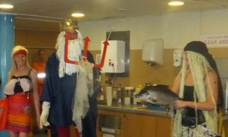
The Royal Visit: King Neptune and his party.
The excitement of the day has continued. Around lunchtime we went hunting through greatly thickened pack ice in search of the Russian tourist ship Akademik Shokalski. By the time we found her she was in open water and had launched her zodiacs (inflatable rubber dinghies carrying six or eight people), packed with tourists who initially were looking at penguins but turned their attention to us when we came into sight. It is a relief to know we are not entirely alone in the Antarctic.
Mid-afternoon we had a briefing about what’s to come over the next few days. It was expected that by early evening we would come up against the fast ice which covers much of Commonwealth Bay and blocks the final lap to Cape Denison. The most likely option was that we would not be able to break very far into the fast ice and therefore will need to fly in the Mawson’s Hut site by helicopter. Those scheduled to fly in, which includes me, need to be ready to go at two hours notice from six o’clock in the morning,
Soon after we were honoured with a royal visit. King Neptune and his court graced us with their presence and subjected a number of our fellow travellers (those who had not previously been south of 60° latitude) to the ritual humiliation common on such occasions.
The candidates were asked (or rather ordered) to “kiss the fish” (the fish was subsequently rubbed all over the initiates’ heads), to “drink the fluid” (some purple concoction which no doubt tasted foul), and were finally rubbed all over (well, almost all over) with some unknown substances which King Neptune maintained represented the wastes which humans had thrown into his oceans. It was all suitably gross and entertaining, and even the initiates came out smiling (at least, after they had had a shower).
We then all gathered on the “trawl deck” at the aft end of the boat (this space is normally occupied by the marine scientists) for the first of several barbecues we have been promised during this voyage. For the first time in a week some alcoholic liquors were available but none of us were able to imbibe very deeply.
The barbecuing was done in a suitably old-fashioned manner; half 44 gallon drums filled with burning wood and topped with steel plates. We rugged up for the occasion, as the temperature was a bit below zero and snow was gently falling in soft fat flakes. But there was a sufficient press of people for some transference of body heat.
While we were relaxing, the Aurora Australis was continuing to move south at a good pace. By the time we were done with the eating and drinking, the ship had reached the edge of the fast ice about which we have heard so much over recent days. What now lay before us was very different to the scenery we had gazed upon ever since we first encountered the pack ice. Even when the pack ice was densest, there was always blue water visible beween the floes, and the surface of the ice was uneven.
Now we gazed upon a vast white plain, smooth beyond a few faint wind-carved ripples in the snow, and stretching unbroken to the horizon, or at least until it merged imperceptibly into a white sky. It looked like land, though of course it was not. The ice, only a metre or two thick under its covering of snow, was floating. But it was still sufficient to prevent, or at least impede, our smooth and rapid passage to Cape Denison.
The initial thought was that we could break through, at least for some distance. So the ship was backed up for a couple of hundred metres, and then sent at maximum speed crashing into the edge of the fast ice. Some of it gave way quickly. But half a dozen attempts took us only a couple of hundred metres into the white plain. It was decided to call it a day.
Further attempts may be made in the morning, but if we do not advance much further, we have a 15 km or more flight to reach our ultimate destination. But that is the purpose to which we have come, at least on this first part of the voyage. We will see what the morning brings, but we are assured of further excitement.