Max Corry – ANARE Club representative 1991 – 1992 VOYAGE 7 ICEBIRD
ANTARCTICA REVISITED – A GENERATION LATER
by Max Corry
For me (a member of ANARE expeditions in the 1960’s) the chance to visit memorable places in Antarctica again was indeed the opportunity of a lifetime. Such was the case when I joined 41 other passengers on the Icebird for voyage 7, its 1991-92 resupply voyage to Davis and Mawson. the itinerary also included a visit to Heard Island to establish a temporary winter station there.
Most people may be aware of the changes over the years but it is difficult to put it all into perspective without actually experiencing it. Reading “Antarctica and back in sixty days” by Tim Bowden provided considerable information, particularly as this book is an account of a very similar voyage some three years ago. One thing has not changed; ships still get stuck in the ice and due to delays on the previous voyage to Casey, our departkure was delayed so Voyage 7 was shortened by eliminating oof-shore work at Mawson.
The Icebird is larger than the Dan ships (6433 tonne deadweight and 2505 tonne nett weight represents a factor of more than two). At 109.6m its length is half as long again and similar ratios exist for the 18.9m width and 7.6m draught. Up to 14.75 knots speed can be attained from its variable switch propeller powered by a 12 cylinder diesel 4200 kilowatt (kW) engine, which can also produce some 800kW of electrical power. This system is supplemented by two 660 kW diesel alternator sets. The vessel is basically an ice-strengthened freighter with three large holds (with continuous hatches) and a sukperstructure aft to accommodate 26 crew. Two cranes, each with a 40 tonne limit working over a radius of 25 metres are located on the port side of the ship. Passenger accommodation is provided by means of a three level (or four if the bar and lounge suspended underneath are considered) self-contained module that is bolted to the ship over the hold immediately forward of the superstructure. Only once has this module been removed, to carry lengths of pipeline to the Alaskan oilfields.
The upper two levels of the module contain 4 berth cabins either with en-suite or shared facilities. The mess, complete with servery and medical centre share the lower level with the machinery neded for the module including the notorious ‘Icebird’ vacuum toilet system. As well as the mess which has video facilities, there is a recreation room on the middle level and a bar and lounge on a level below the mess. The module is connected to the superstructure by by a companionway at the lower level facilitating the transfer of food from the galley located in the superstructure. Because of the accommodation module, little cargo is carried in the third (aft) hold. The ‘tween decks are used for hand cargo and ship’s food and the actual hold itself is used for a games area, complete with table tennis, badminton and a couple of exercise bikes. Signs of use are beginning to appear, particularly the storage fittings in the passengers cabins. Perhaps it was the Icebird that Vitali Vitaliev saw when he noted in his book ‘Vitali’s Australia’ that Constitution Dock was where ‘the tired hulks of ice-breakers from the Antarctic come to rest’!
As all passengers are required to be in Hobart a day or so before departure, some time was available to observe the loading activities. Down at the whare, the sheer size of the cargo to be transported contrasted sharply with the earlier dys of ANARE, with some individual items ranging up to nearly 29 tonnes. Numerous vehicles and huts/shelters were conspicuous as were the number of shipping containers. These containers, some with self-contained refrigeration units, are stacked kup to four layers high on the hatches just forward of the living module. One wondered how this arrangement, which really seemed out of place to the uninitiated, would perform in the turbulent waters of the Southern Ocean. Added to all this was the bulk cargo of nearly one million litres of assorted fuels.
Two days were spend in Hobart which included receiving the kit issue for a round tripper and an extensive briefing; more elaborate that the earlier ANARE ones and with particuklar emphasis on safety at sea. This was reinforced by a compulsory trip on the Derwent in one of the Icebirds four covered life boats. It was a good opportunity to meet some of one’s fellow travellers, including a media component and representatives from the British Broadcasting Corporation. With most of the summer expeditioners and the 1992 winterers already down south, the other passengers, including (in Tim Bowden’s words) ‘a sprinkling of women’, were those with varied projects or reasons fortunate enough to gain a berth. Included were a couple of other vintage expeditioners or ‘old sweats; John Manning from Mawson 1967 and numerous summer survey seasons and Attila Vrana destined to spend 1992 with four others at Heard Island, the first ANARE party to winter there since1954. Both Attila and myself started our Antarctic experience together at Mawson in 1965 and had crossed paths regularly since then. To put that period into today’s perspective, an item returned to Australia on the previous voyage from Casey was part of Old Casey’s kitchen now destined for the museum. We predated that by years. No wonder the ‘old sweats’ on board were knows as the ‘fossils’.
Finally the record cargo was loaded, resulting in the ship being very low in the water. So low in fact that moderate or heavier seas prevented access to most of the deck including the hold containing ship’s supplies, until smoother seas were encountered. Most of the ship’s movement was in pitching with little rolling but the heavy load proved to be a mixed blessing. The ship’s progress was initrially slow, but it speeded up to its maximum cruising speed on reaching the Antarctic Convergence. The only pack ice encounered was a small amout off Davis.
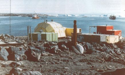
The voyage into Davis on Sunday 9 February was on one of those balmy days with magnificent weather and conditions. The glistening icebergs gave us a splended welcome to the continent, especially to those who had been up to see the sun rise. The Chinese Antarctic supply ship Ji Di was at the Davis anchorage as there are no long-term moorings available in the Larsemann Hills, site of the Chinese Zhongshan station.
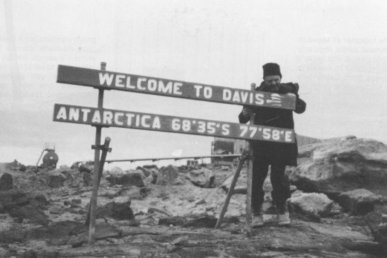
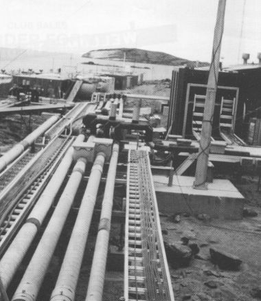
I was staggered by the sight of Davis, particularly as the only time previously I had been there was in February 1966 when it was temporarily closed. In direct contrast to the description ‘Davis station is possibility Antarctica’s smallest establishment’ in the 1957 book ‘ANARE – Australia’s Antarctic Outposts’, it is now like a big mining or construction camp (Tim Bowden referred to it as ‘a bit like a Mt Isa mining camp with a few icebergs in the background) with huge buildings, interconnecting dirt roads and a mutitude of wheeled and tracked vehicles; more elevated pipes than a small oil refinery and bridges for the traffic (both vehicular and foot) to pass over. There is even a quarry and rock crushing plant for the rebuilding programme. one comment from an ‘old sweat’ expressed it all – ‘no longer do we have a small toehold on Antarctic sites, we are conquering the area with massive site adaption’! At Davis we renewed acquaintance with the venerable old man of Antarctic communications, Doug Twigg, who has lost count of his trips to Antarctica since his first in 1956. Doug joined us for the trip back to Australia after completing the summer at Davis.
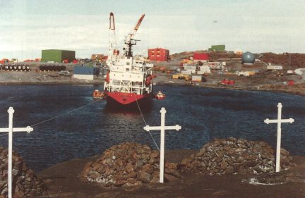
Davis anchorage with ‘Icebird’ and ‘Ji Di”
Davis ‘Pipelines’
Davis is well known for its location on the ice-free “oasis” or dry valleys of the Vestfold Hills, which are a classic example of a dyke-dissected terrain dotted with several hundred lakes. The hills consist of a sequence of 2.5 to 2.8 billion years old gneisses with a east northeast – west southwest foliation, intruded by several groups of vertical metabasalt dykes of many ages in the 2.5 to 1.4 billion year range and with a variety of orientations but generally north-south. Davis is also ideally placed for studying how the solar wind reacts with the earth’s magnetic field as it is under the magnetospheric cusp around magnetic noon. Davis and the South Pole stations are the two continuously occupied southern hemisphere stations that are ideally located for these studies.
Included in the cargo was 120,000 litres of fuel for Davis (most of the station’s 1992 fuel requirements had been delivered on an earlier voyage using a pipeline laid out across the sea ice from the ship) and 1900 cubic metres of general and rebuilding cargo. The unloading was accomplished in two days using three amphibious Army LARC’s three ANARE water-jet propelled barges, the ship’s boat and a dumb fuel barge of 40,000 litres capacity. These required the attention of the ten person army team as well as many shore based expeditioners who supplemented the unloading with motorised crane, fork lifts, and Caterpillar vehicles and trailers. Gone are the days of expeditioners manually lifting fuel drums from the well of a DUKW, the predecessor of the LARC; however, some of the containers have to be unpacked by hand which I experienced later when helping move the ‘goodies’ into ‘Fort Knox’ at Mawson. In spite of all this disturbance there are still some elephant seals in the wallow at the southrn end of the old landing beach. The infrastructure extends to an earth wharf just to the south of the main beach connected by a major road to the station. Davis now consists of some 40 structures, the majority of which are considered ‘old station’. The road system extends 6km out from the station towards Airport Beach, a place I visited in a conventional 4 wheel drive vehicle. Another road, about 1km, leads from the station to Marchant’s Landing on the northern arm of Heidermann Bay (south of the station) and is an alternative facility for cargo transfer when sea ice conditions prevent use of the main beach and wharf approach. In fact, tracked vehicles are much in the minority at Davis, and even motorised toboggans have been replaced by four wheel all-terrain motorbikes commonly known as ‘quikes’ or ‘quads’.
Most of the passengers on the Icebird were not part of the specialised unloading programme so groups of three (including a guide from Davis) were deposited, usually by helicopter, at various huts in the Vestfold and Larsemann Hills to sample the local delights. At present huts exist at Watts Lake, Trajer Ridge, Platcha, Brookes (on the southern shore of Shirokaya Bay – part of Long Fjord), Bandits and Magnetic Island and on Hop Island in the Rauer Islands.
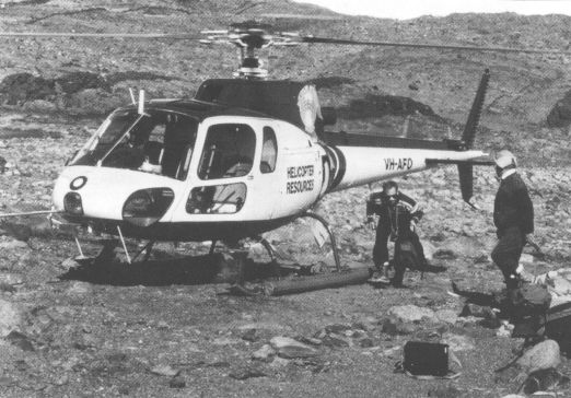
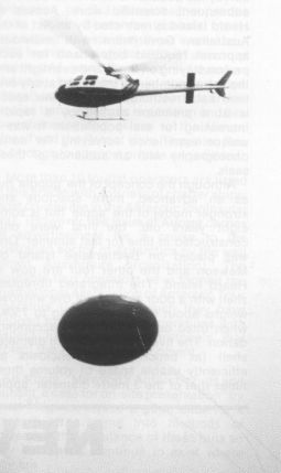
Transport was provided by two Aerospataile (now Eurocopter) Squirrel helicopters based at Davis during the summer for program support in the Vestfold Hills – Rauer Islands – Larsemann Hills coastal regions.
I spent two nights at Watts Hut near Ellis Rapids, a sight in itself with the water tumbling over a distance of sixty metres, five metres vertically from Druzhby Lake to the head of Ellis Fjord. A rudimentary flying fox consists of a metal chair on steel cables has been rigged across a narrow part to allow crossing at times of high water flow.The intervening day was spent walking to Deep Lake and climbing Tarbuck Crag, the highest point in the western part of the Vestfold Hills and site of an ANARE wind and solar powered Very High Frequency (VHF) radio repeater station. This was again another revelation with the performance of lightweight hand held radio equipment. The evening radio sked confirmed that regular VHF communication is possible as far south as the Larsemann Hills. In fact we carried the radio as well as back packs, sleeping bags and the like. This is now a requirement when leaving defined areas.
Helicopter in Vestfold Hills
Davis anchorage with ‘Icebird’ and ‘Ji Di”
The final two days at Davis were spent just coming to grips with the changes. The old station is now only a small portion of the present station with summer expeditioners, station leader, radio and met being accommodated there. Most of these functions will be accommodated in the new operations building now under construction but there are already murmers that this building will not be big enough. After wandering around these high buildings (the stores are stacked 10 metres high inside just one building), I found in the vehicle park another relic, an R.M.I.T. caravan, similar to the two that four expeditiioners spent the winter in on the Amery Ice Shelf in 1968. It looked out of place, but I was glad to see this link with the earlier days. The line of equipment in the vehicle park included two 7 metre work-boats for working in inshore regions within 30km of Davis.
Buildings now completed include the living quarters containing medical facilities and mess, store, garage and powerhouse, sewage treatment facility (completed in the 1990-91 summer) as well as the first of three 600,000 litres water tanks. The upper atmospheric physics building is scheduled for completion in 1992 and the general science building a year later. Completion of the operations building is planned for 1992-93 with the finish of the building program scheduled for 1994. Removal of superseded buildings is planned for 1993-94 and subsequent years, following assessment of heritage considerations. In spite of the rebuilding program the water problem still exists, particularly during the summer peak, requiring rationing and the use of inferior water from the nearby Station Tarn. The current snow melter capacity is 15,000 litres. The planned water storage capacity of 1.8 million litres is just above estimated annual consumption of 1.6 million litres. Other solutions proposed include a reverse osmosis plant and a retractable poly-pipe line frm Ellis Rapids 12 kilometres away (some people have some environmental concerns over this latter proposal).
Excitement and then anger were caused by the sighting of Japanese whalers operating very close to Davis without acknowledgment, just like the scenario with the ‘Wilkaditurn’ described by Tim Bowden. Even the minke whales that had accompanied the Icebird into Davis were probably no longer alive. Quite a deal of justified flurry emerged over this completely repugnant action in the so called name of scientific research and left us somewhat sick in the stomach, angered and frustrated, particularly after viewing a video taken from the Australian helicopter. And to learn later that the Japanese on Australian television justifying their actions in taking a reported catch of 288 minke whales during the summer and strongly advocated a return to commercial whaling of their estimated population of 750,000 minke whales!
Our Navy contingent of six complete with a hydrographic boat were in search of the elusive quarry ‘Thala Rocks’ described in the 1965 Gazetteer of the Australian Antarctic Territory as ‘an isolated, submerged rock about 500 metres from Turner Island with probably no more than a fathom (2 metres) of water over it and named after Thala Dan which first struck it on 16 January 1959. The rock was found to be a pinnacle in some 3 metres depth of water abvout 150 metres from its previously plotted position. The pinnacle, in fact, is on a rock platform some 150 metres long and 75 metres wide which rises abruptly from the ocean floor and is covered by some 11-12 metres of water. The whole area was found to have a number of shoals at various depths.
The ship took two days to travel to Mawson, during which time several impressive natural phenomena were witnessed. Numerous icebergs from the Amery Ice Shelf were grounded on the Fram Bank, defined by the charted 183 metre line and with a minimum depth of 88 metres. The outlines of the grounded icebergs were clearly discernible on the ship’s radar screen.
None of these in size approached the giant iceberg that broke off the Amery in 1963 which incidentally, in volume represented twice the amount of ice discharged annually from the whole continent. Later the peaks around Scullin Monolith and the Gustav Bull Mountains on the Mawson Coast were clearly seen in the distanace. The ship then waited for sunrise before heading south through ‘Iceberg Alley’ to Mawson. The ‘Antarctic Pilot’ notes this as the ‘Mawson Corridor’, describing it as a natural deep-water channel passing through banks of less than 183 metres depth with many icebergs usually grounded on the banks providing a clear indication of the channel ahead.’ the rows of icebergs glistening in the sunshine and the wind brought back fond memories of 27 years ago when I first arrived at Mawson, with the familiar backdrop of the picturesque Frammes Mountains. The ship stopped before entering Horseshoe Harbour and unloaded the LARCs and the ship’s boat which then accompanied the ship in so that the eight mooring lines were attached without delay. Only by using the bow thruster can a ship the size of the Icebird manoeuvre in the restricted space of the 300 metre wide harbour.
During the first evening at Mawson, a group of round trippers were taken by Hagglund all terrain vehicle to Rumdoodle in fairly overcast conditions. The considerable melt during the summer had caused vehicular access to the plateau to be changed from the traditiional route via West Bay to a route over the rock behind the station and then up from East Bay. There had been considerable effort put into remarking this route to the plateau with 200 litre drums. Walking on the polished ice could only be achieved with the traditional crampons. The lateness of the hour prevented a visit to either Mount Henderson or Fang Peak in the northern David Range, sites of the other two field huts in the Frammes Mountains. Again the instant VHF radio communication was to the fore (just like radio taxis back home) with repeater sites on Mount Twintop and Depot Peak, allowing VHF coverage all the way to the Prince Charles Mountains. During the unloading programme there were up to four separate VHF channels (frequencies) in operation, each covering a facet of the operation in progress.
It is in fact the two-way radio work with aircraft, vehicles and field parties that consume much of the radio effort, particularly over the summer season. Gone are days of four operators working 50 skeds a day at Mawson with teletype and morse key transmitting weather traffic from a number of neighbouring Antarctic stations plus administrative and personal traffic. With satellite communications, the traffic goes direct from each statioin and the ‘phone system is kept busy between the stations, Kingston and the rest of the world with the result that only two communication officers winter over there now. The only regular radio skeds are a couple a day for meteorological data transfer with the Japanese station Showa. No more blackouts due to ionospheric conditions affecting the High Frequency (HF) bands. The HF transmitters are still at Mawson with 3 Rockwell HF/Collins 8022 transmitters physically much smaller but just as powerful as the 10kW CTH7 transmitters of the sixties. In this age of satellite communications even these current transmitters dwarf the typical 1 kilowatt or so transmitters now found on most of the other Antarctic stations. Another interesting device was the ‘simplex telex over radio’ used for communication with field bases such as Dovers in the northern Prince Charles Mountains. Physically, the effect of the introduction of the satellite communication system is more noticeable outside the radio buildings with half of the high aerial masts destined to be removed by teams of Army riggers who were at Mawson during the past summer. The satellite system has also allowed more automatic collection of data which is sent instantaneously back to Australia. This, coupled with an extended summer season resulting from more and earlier ship visits, has resulted in a reduction of the number of wintering scientists compared with previous decades but allows for more scientists over the summer, which this year reached an all-time high figure of 160.
In contrast to the sole Ferguson tractor and one two-ton trailer available for unloading in the late 1960’s, even more mechanical equipment is used at Mawson than at Davis. Working with two shifts, the 2700 cubic metres of general and rebuilding cargo were unloaded in two days plus 700,000 litres of fuel through twin 75mm diameter pipelines from the ship across the harbour to the fuel farm.
As at Davis there have been many changes with hugh buildings, interconnecting roads complete with bridges and the rock wharf. Many of the boulders and the uneven rock that proved such obstacles to the early changeovers have disappeared, literally, down the now common rock crusher. Most of the 48 buildings there in 1965 still remain, but many are now under utilised. Some have even been shifted to new locations from those that I remembered. The aircraft hangar has had a new lease of life (the door system is operational again) and serves as a store for large items. Naturally, the ‘old sweats’ preference was for Law Hut, still going strong during the summer peak and one of the five buildings (probably Shackleton, Weddell, Biscoe, Law and the electrician’s hut) that are proposed to remain as historic monuments. This is of particular importance as Mawson is the oldest continuously operating mainland station in Antarctica. I suspect ‘Shackleton’ has been included in this proposal rather that the older ‘Ross’ and ‘Balleny’ huts (according to the 1957 book ‘ANARE -Australia’s Antarctic Outposts’) because of its proximity to the original buildings and hence the greater convenience to form a more compact group of buildings. The former survey office in ‘Rymill’ the original administrative building has been reduced to half its 1965 size to service radio technology and the rest of the building, instead of separate offices and sleeping cubicles, is one warm store for food. In the existing recreating room (known as ‘The Club’) there is a sketch from that location towards the new buildings, the title ‘A view from the Ancient Quarter to Mawson Heights’ which says it all. Further afield the original meteorological office, ex Heard Island, now serves as a meteorological workshop and store.
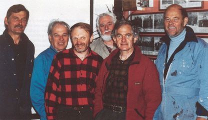
The ‘Fossils’ at Mawson – from left: Attila Vrana, Doug Twigg, Max Corry , Charlie Weir, Jim Hasick, John Manning.
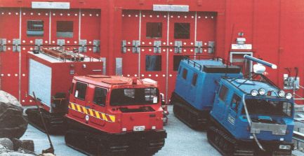
Mawson fire station
Even the now twenty years old, Cosmic Ray building was a novelty to me. This observatory is situiated to the southwest of the general station complex on the hill at the base of West Arm (Attila Vrana claims it has the best view in the place). It is the largest of its type in the southern hemisphere and included the only underground (11 metres below the surface) cosmic ray observatory operating in polar latitudes. West of this building is the only outcrop of the Mawson rock still undisturbed by station activities. In the original state Mawson rock could be described as a moraine-mantled, ice-polished charnockite.
The new buildings have exterior colours according to their functions: sleeping and living, red (hence the ‘red shed’); stores, (including water) green; operations, yellow; engineering (such as the powerhosue) blue and so on in a consistent manner to facilitate easy identification. Of these new buildings the store has been erected but requires fitting out. The sleeping and medical quarters building was completed in 1984. The living quarters extension, of seemingly immense proportions to accommodate the mess and recreation area, is in the process of construction for completion next summer. The new power house is complete. The science block is due to start this year and an operations building is scheduled for completion in 1994-95, at which time removal of some of the older disused buildings, not listed as of heritage value, will commence. There are some expeditiioners who prefer the freedom allowed by the old sleeping huts in the western suburbs’ (including the ability to open a window) and so they use these in preference to the new living quarters. Some of the internal partitions in the old dongas have been removed to provide space for lounges, studios and other requirements.
Gone is another activity which used to bring all the station staff together in the form of the daily snow collection (by hand) for the kitchen melter. Water is now produced during the summer melt and collected in “caverns” where it is maintained in liquid state by heat from a boiler in the pump building and waste heat through heat exchangers from the station’s diesel electric genertors. Two large storage tanks fully enclosed within a special building are kept at lease half full in order to provide an adequate supply of water for fire fighting. For this latter function an auxiliary diesel engine within the tank building maintains water pressure in the event of electrical power failure.
The whole plumbing system is kept heated to prevent freezing, which would occur in half an hour during winter. For this and other critical functions that depend on electrical power, the power house is now out of bounds to everyone except authorised personnel. The whole engineering system is constantly monitored by dedicated computers and an extensive fire alarm system.
The range of vehicles is substantial. Even the fire fighting appliances have changed signifcantly. There is a dedicated tracked Hagglund tender, complemented by a smaller trailer unit that can be towed by a quike (the all terrain bike) plus several portable units. Most of the larger vehicles not only have VHF radio fitted but also radar and now Global Positioning System receivers which use special satellites for navigation.
